

Click on the little pictures to enlarge them.
The city has been called "Istanbul" by its inhabitants since the Ottoman conquest in 1453, but the change from Constantinople was not made "official" until 1930.
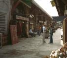
| The various bazaars of modern Istanbul are fun to visit. The covered bazaar is huge but crowded, and difficult to photograph. This is one of the open-air bazaars. |

|

|
Istanbul is one of the most interesting cities in the world; there are many more things to see than these pictures show. Turks are generally warm, friendly people, and our visit was fun as well as interesting. A smattering of Turkish is useful. We spent some time with the Language/30 package from Educational Services Corporation (two tapes and a phrase-book) and found it worthwhile. Unfortunately this excellent series seems to be going out of print.